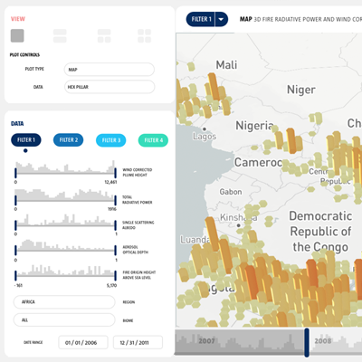
The Multi-angle Imaging SpectroRadiometer (MISR) instrument on NASA’s Terra satellite has been collecting global wildfire smoke plume data for over a decade. The MISR team seeks to make this extensive database as accessible to scientists as possible to enable investigations of wildfire impacts on climate and air quality.
In our collaboration, we sought to create a more widely accessible, explorable representation of NASA’s MISR instrument fire plume data.
We created an interactive visual solution that allows researchers to explore the complete database in depth including geography, plume height, fire radiative power, and other appurtenant metrics.
Outcomes
MISR FIRE PLUMES: to be deployed on the NASA MISR archive page.
See also: Boone, J. T., Tosca, M., Galvin, A., Nastan, A., Schurman, D., Nair, P., S. Davidoff, S. Lombeyda, H. Mushkin, & Hendrie, M. (2018, December). Redesigning for Research: Accessible Data Interaction with MISR Fire Plumes. In AGU Fall Meeting Abstracts.This project was also featured in a NASA/JPL Education article, “Seeing Science: Using Visualizations to Help NASA Study Wildfires:†https://www.jpl.nasa.gov/edu/news/2018/10/15/seeing-science-using-visualizations-to-help-nasa-study-wildfires/